Topographic Map
Also called: topo map, topo, USGS quad, quadrangle, 7.5 minute quad
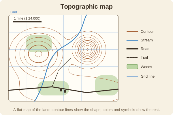
A map that shows the shape of the land with contour lines, along with trails, roads, water, and woods. It is the main tool for planning and following a route.
- Type
- Maps & Grids
- Common U.S. series
- 7.5-minute USGS quadrangles, usually at 1:24,000 scale
- Shows
- Elevation, slope, streams, lakes, roads, trails, buildings, and land cover
- Margin
- Scale bars, contour interval, declination diagram, and the datum and grid used
- Where to get one
- Free downloads from USGS, topo apps, and printed maps from outdoor stores and agencies
- Used for
- Hiking & camping, Hunting, Fishing & boating
What it is good for
- Planning a hike, hunt, or paddle and judging how steep it is.
- Spotting ridges, valleys, saddles, creeks, and likely game or fish areas.
- Backup navigation when a phone or GPS fails.
Where it falls short
- Maps age: trails, roads, and forests change faster than the printed date.
- A topo does not show every trail or fence, and it may not show who owns the land.
- Paper tears and gets wet unless you protect it.
Tips
- Check the date and the datum in the margin before you go.
- Mark your start point, a few key checkpoints, and any bail-out routes before leaving.
- Keep it in a zip bag, and fold it so your route area shows.
Works well with
- Contour Lines: how to read the shape of the land.
- Map Scale: converting inches to miles.
- Map Symbols and Legend: what the colors and signs mean.
Field notes
A topographic map flattens a three-dimensional landscape onto paper by drawing lines of equal elevation. Once you can read those lines, a map tells you where the climbs are, where a creek runs, and where you can cross easily.
Related guides
Numbers here are typical, and values such as magnetic declination change over time and place, so check a current source such as NOAA or your map's legend. Practice near home before you rely on a skill far from help, carry a paper map and compass as a backup, and tell someone your plan. Rules on electronics, land access, and trespass differ by state; our state resources directory links to each state's official regulations. Want a step-by-step guide? Read Trail Navigation Basics.