
Contour Lines
Also called: contours, contour interval, index contour, elevation lines, saddle, ridge, valley
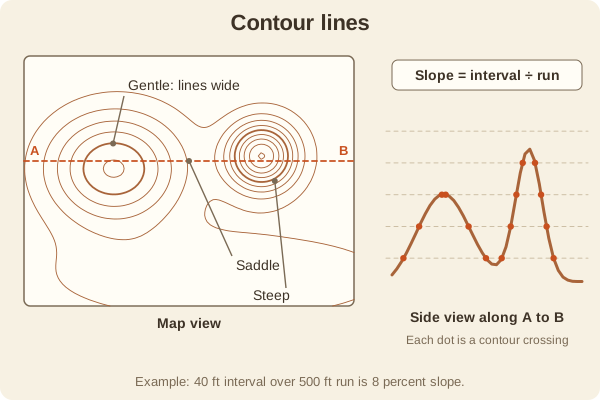
Each contour line joins points of the same elevation. How close the lines are shows how steep the ground is, and their shapes show hills, valleys, and ridges.
- Type
- Maps & Grids
- Contour interval
- Elevation change between lines, often 10, 20, or 40 feet; printed in the map margin
- Index contours
- Every fifth line is bolder and labeled with its elevation
- Valley
- Lines form a V that points uphill, often with a stream
- Ridge
- Lines form a U or V that points downhill
- Saddle
- An hourglass shape between two high points
- Used for
- Hiking & camping, Hunting, Fishing & boating
What it is good for
- Judging how hard a climb will be before you start.
- Finding a gentle route around cliffs or steep sides.
- Spotting benches, saddles, and funnels used by game.
- Reading lake depth maps, which use the same idea underwater.
Where it falls short
- The interval hides small features between the lines.
- Lines that touch or merge usually mean a cliff.
- Dense forest or a gully can be steeper or rougher than the lines suggest.
Tips
- Find a stream first, because the contour V's point upstream.
- To estimate slope, divide the contour interval by the horizontal distance between two lines. A 40-foot interval with lines 500 feet apart is an 8 percent slope.
- Trace your route and count the contour lines you cross to total the climb.
Works well with
- Map Scale: needed to measure the spacing between lines.
- Topographic Map: the map type that uses them.
Field notes
Imagine slicing a hill into thin layers at fixed heights and looking straight down at the edges. Each edge is a contour line. Where the hill is steep the edges bunch together, and where it is flat they spread out.
Related guides
Numbers here are typical, and values such as magnetic declination change over time and place, so check a current source such as NOAA or your map's legend. Practice near home before you rely on a skill far from help, carry a paper map and compass as a backup, and tell someone your plan. Rules on electronics, land access, and trespass differ by state; our state resources directory links to each state's official regulations. Want a step-by-step guide? Read Trail Navigation Basics.