
Satellite Communicator
Also called: satellite messenger, inReach, SOS beacon, PLB, two-way satellite messenger
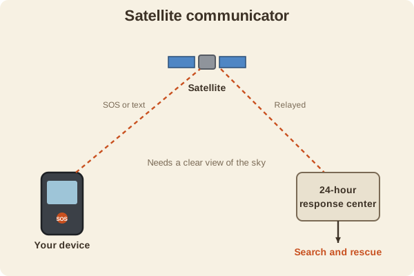
A small device that sends texts and an SOS call through satellites when you have no cell service. It is for emergencies and for staying in touch off the grid.
- Type
- GPS & Devices
- How it works
- Talks to satellites instead of cell towers, and passes an SOS to a 24-hour response center
- Needs
- A clear view of the sky, and usually a monthly or yearly plan
- Types
- Two-way messengers with texting, and personal locator beacons (PLBs) that only send a distress signal
- Extras
- Location sharing, weather forecasts, and a basic tracking trail
- Used for
- Hiking & camping, Hunting, Fishing & boating
Safety: Use SOS only for a real emergency. Help depends on your battery, your view of the sky, and conditions, so it is not a reason to take bigger risks.
What it is good for
- Remote hunting, hiking, fishing, and paddling trips with no cell service.
- Letting family follow your progress and check in.
- Calling for help after an injury or a serious problem.
Where it falls short
- A monthly plan costs money, and messages are short.
- Trees, canyons, or a hood over the unit can block the signal.
- An SOS does not mean help arrives instantly; rescue takes time.
Tips
- Test messaging before the trip, and carry it where you can reach it, not buried in a pack.
- Keep the battery charged, and bring a way to recharge on long trips.
- Share your plan with your contacts, so they know when to worry.
Works well with
- Handheld GPS: gives position, but cannot call for help.
- STOP When You Are Lost: the steps to take before you need to call.
Field notes
A satellite communicator is a safety link, not a navigation tool. It tells rescuers where you are, but you still need to plan, navigate, and prepare to wait.
Related guides
Numbers here are typical, and values such as magnetic declination change over time and place, so check a current source such as NOAA or your map's legend. Practice near home before you rely on a skill far from help, carry a paper map and compass as a backup, and tell someone your plan. Rules on electronics, land access, and trespass differ by state; our state resources directory links to each state's official regulations. Want a step-by-step guide? Read Trail Navigation Basics.