UTM Grid
Also called: UTM, universal transverse mercator, MGRS, easting, northing, grid coordinates
A grid laid over a map in meters. You read a position as an easting (how far east) and a northing (how far north), which makes measuring easy.
- Type
- Maps & Grids
- Zones
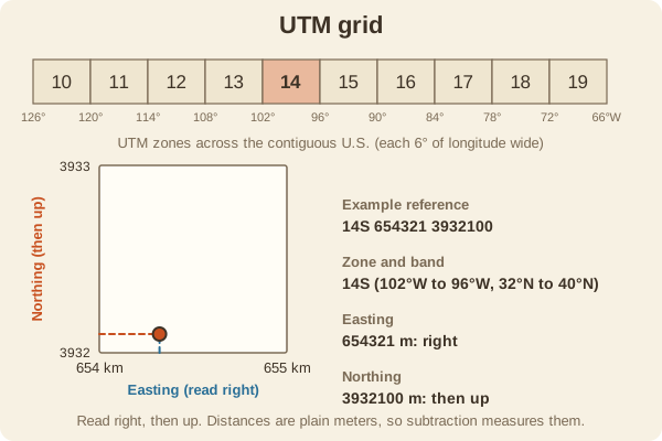
- 60 zones, each 6 degrees of longitude wide; the contiguous U.S. spans zones 10 to 19
- Example zone
- Zone 14 covers 102 to 96 degrees west
- Reading order
- Easting first (read right), then northing (read up)
- Grid squares
- Often 1 km on a 7.5-minute topo map, with the lines printed in blue
- Example
- 14S 654321 3932100 gives zone 14, band S, easting, northing
- Used for
- Hiking & camping, Hunting
What it is good for
- Finding a position on a topo map to within about 100 meters or better.
- Search and rescue, land managers, and hunters who share coordinates.
- Using a grid reader (a plastic ruler) with a map.
Where it falls short
- You must know the zone, and the zone changes at a boundary.
- Different map datums give slightly different values, so match the GPS to the map.
- Not everyone uses it; many people only know latitude and longitude.
Tips
- Use a plastic grid reader, or just estimate tenths between lines.
- Always say 'right, then up' to yourself before reading a grid reference.
- Set the GPS to UTM and the same datum as your map.
Works well with
- Latitude and Longitude: the angle-based alternative.
- Magnetic Declination: grid north is a third north to account for.
Field notes
Because UTM uses meters, measuring a distance between two points is simple subtraction. That is its big advantage over degrees, where a degree of longitude is a different length at every latitude.
Related guides
Numbers here are typical, and values such as magnetic declination change over time and place, so check a current source such as NOAA or your map's legend. Practice near home before you rely on a skill far from help, carry a paper map and compass as a backup, and tell someone your plan. Rules on electronics, land access, and trespass differ by state; our state resources directory links to each state's official regulations. Want a step-by-step guide? Read Trail Navigation Basics.