

Magnetic Declination
Also called: declination, magnetic variation, true north, magnetic north, grid north
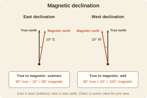
Declination is the angle between true north (the geographic pole) and magnetic north (where a compass needle points). It changes with place and slowly over the years.
- Type
- Compass
- Three norths
- True north (the pole), magnetic north (the needle), and grid north (the map's vertical grid lines)
- True to magnetic
- Subtract east declination; add west declination
- Magnetic to true
- Add east declination; subtract west declination
- Range in the contiguous U.S.
- Roughly 15 degrees east in the Pacific Northwest to roughly 15 degrees west in northern New England
- Where to find it
- NOAA's online calculator, or the diagram in your map's margin (which can be out of date)
- Used for
- Hiking & camping, Hunting, Fishing & boating, Sun & stars
What it is good for
- Making a map bearing match what your compass needle shows.
- Avoiding a growing sideways error over long distances.
- Anyone using a paper map with a compass.
Where it falls short
- The value changes over time, so an old map's number may be wrong.
- Declination is only one source of error, along with steel nearby and a tilted compass.
- Near the poles and in some local spots it is large or unreliable.
Tips
- Look up the current value for your area before the trip and write it on your map.
- If your compass has an adjustable declination screw, set it once and then you can read map bearings directly.
- A handy rhyme: east is least (subtract), west is best (add), when going from a map bearing to a compass bearing.
Works well with
- Taking a Bearing: where the correction is applied.
- Orienting a Map: uses the same correction.
- UTM Grid: grid north is the direction of its vertical lines.
Field notes
A compass needle follows Earth's magnetic field, and the magnetic pole is not at the geographic pole. If you ignore declination, a 10-degree error will put you about 930 feet off line after one mile.
Because the value drifts a little each year, treat the number printed on an older map as a hint and look up a current one.
Related guides
Numbers here are typical, and values such as magnetic declination change over time and place, so check a current source such as NOAA or your map's legend. Practice near home before you rely on a skill far from help, carry a paper map and compass as a backup, and tell someone your plan. Rules on electronics, land access, and trespass differ by state; our state resources directory links to each state's official regulations. Want a step-by-step guide? Read Trail Navigation Basics.