
Latitude and Longitude
Also called: lat long, coordinates, decimal degrees, degrees minutes seconds, DMS, DDM
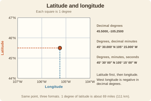
A coordinate system that gives every place on Earth two numbers: latitude (north or south of the equator) and longitude (east or west of the prime meridian).
- Type
- Maps & Grids
- Latitude
- 0 degrees at the equator to 90 north or south; one degree is about 69 miles (111 km)
- Longitude
- 0 degrees at Greenwich to 180 east or west; the distance of a degree shrinks toward the poles
- Three formats
- Decimal degrees (35.5000), degrees and decimal minutes (35 30.000), and degrees, minutes, seconds (35 30 00)
- U.S. longitude
- West, so decimal values are negative (for example -97.5)
- One minute of latitude
- About one nautical mile, or 1.15 statute miles
- Used for
- Hiking & camping, Hunting, Fishing & boating, Sun & stars
What it is good for
- Sharing a location with a rescuer, dispatcher, or friend.
- Entering a destination into a GPS or phone app.
- Boaters and anglers marking spots on a lake or coast.
Where it falls short
- Mixing up the formats puts you miles away, so set your GPS format to match the source.
- Forgetting the sign or the W gives a point on the wrong side of the world.
- Older maps may use a different datum, which shifts the position.
Tips
- Write the format down with the numbers, for example '35.5, -97.5 decimal'.
- Latitude lines run east-west; remember it as 'ladder rungs'.
- When you tell a 911 dispatcher your position, read the digits slowly and give the format.
Works well with
- UTM Grid: a meter-based alternative that is easier to measure on a map.
- GPS Accuracy and Battery: includes the datum setting.
Field notes
Latitude and longitude are angles. A GPS gives you the pair, and a paper map prints them along its edges, so you can plot a point by finding where those two lines cross.
Related guides
Numbers here are typical, and values such as magnetic declination change over time and place, so check a current source such as NOAA or your map's legend. Practice near home before you rely on a skill far from help, carry a paper map and compass as a backup, and tell someone your plan. Rules on electronics, land access, and trespass differ by state; our state resources directory links to each state's official regulations. Want a step-by-step guide? Read Trail Navigation Basics.