Plat Maps and Land Ownership
Also called: plat map, property boundaries, public land, private land, land access, parcel map
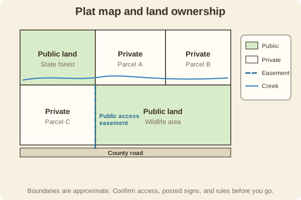
Plat and ownership maps show who owns each parcel and where public land begins. They matter for hunters, hikers, and anglers because a topo map usually does not show it.
- Type
- Maps & Grids
- Where to find them
- County assessor or GIS sites, agency maps (forest, BLM, state wildlife areas), and land-ownership map apps
- Shows
- Parcel lines, owner names, public land, easements, and public access points
- Not guaranteed
- Boundaries are approximate, and ownership can change
- Used for
- Hunting, Hiking & camping, Fishing & boating
What it is good for
- Confirming you are on public land before you hunt, hike, or fish.
- Finding legal access routes and public easements.
- Avoiding trespass on private inholdings.
Where it falls short
- Even good data is not survey quality, so a line on a screen is not a legal boundary.
- Access rules still apply on public land, such as seasons and vehicle restrictions.
- Phone apps can be wrong near edges and fall out of date.
Tips
- Stay well inside the boundary, and look for posted signs, fences, and boundary markers.
- Check your state's trespass and access rules, and ask the landowner if unsure.
- Save the map offline, since signal is often poor on the best public land.
Works well with
- Topographic Map: shows the terrain these boundaries sit on.
- Phone Navigation Apps: many land-ownership layers live in apps.
Field notes
Trespass laws differ from state to state, and not knowing where the line is does not excuse crossing it. Checking an ownership layer is a quick way to plan a hunt, and our state resources directory links to each state's official agencies.
Related guides
Numbers here are typical, and values such as magnetic declination change over time and place, so check a current source such as NOAA or your map's legend. Practice near home before you rely on a skill far from help, carry a paper map and compass as a backup, and tell someone your plan. Rules on electronics, land access, and trespass differ by state; our state resources directory links to each state's official regulations. Want a step-by-step guide? Read Trail Navigation Basics.