
Orienting a Map
Also called: set the map, orient map, line up the map, map and compass
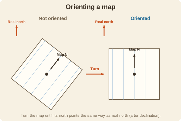
To orient a map is to turn it so the north on the map points to north on the ground. Then every feature on the map lines up with what you see.
- Type
- Techniques
- With a compass
- Set declination, lay the compass on the map with its edge on a north-south line, and turn the map until the needle sits in the orienting arrow
- Without a compass
- Match two or more features you can see, such as a road and a ridge, to the map
- Why it helps
- Everything on the map lies in the same direction as in real life
- Used for
- Hiking & camping, Hunting, Fishing & boating
What it is good for
- Working out which hill on the map is the one in front of you.
- Starting any navigation problem on the right foot.
Where it falls short
- It only works if the map matches the ground, so an old map can fool you.
- A compass held near steel gives a wrong north.
Tips
- Do it every time you stop to check the map, and keep the map flat and level.
- After orienting, hold the map so your thumb marks your best guess of where you are.
Works well with
- Magnetic Declination: must be accounted for when using a compass.
- Triangulation (Resection): the next step to find your position.
Field notes
An oriented map is easy to understand because left on the map is left in real life, and a distant peak sits in the same direction on paper as in front of you.
Related guides
Numbers here are typical, and values such as magnetic declination change over time and place, so check a current source such as NOAA or your map's legend. Practice near home before you rely on a skill far from help, carry a paper map and compass as a backup, and tell someone your plan. Rules on electronics, land access, and trespass differ by state; our state resources directory links to each state's official regulations. Want a step-by-step guide? Read Trail Navigation Basics.